
The first job that I had out of graduate school was mapping landslides. The Federally funded project was administrated by the South Dakota Geological Survey and was focused initially on the Interstate 90 right-of-way at the Missouri River crossing in the central part of the state. The work subsequently expanded to include multiple landslide areas north and south along the steep walls of the river valley. That was in the late 1960s and I’ve never worked on landslides since then.
But in the past several years, the bluff just north of our house has had three landslides that occurred in a clear succession from east to west. Geologic processes are notoriously slow and consequently geologic history is highly interpretive. Even though I didn’t watch the landslides slump down into the Creek, it’s very obvious that they didn’t all happen at the same time. It’s also pretty clear that the landslides are the result of channel erosion and deposition associated with the high water levels of the last two years.

This is a relatively new landslide that displays the classic components: the slip face is where the blocks were originally located; the slump block complex shows that the landslide came down as a series of individual pieces; and the active toe is the area where the moving water removed the soil so the next block could slide down. The two sand bars illustrate where the channel was located when the active sliding occurred. The current open water is located to the right of the new sand bar. The roots of the tree on the right probably provided an anchor that limited the landslide in that direction.
Here’s an older landslide that’s located just to the left (east) of the new one. It’s not active, so the slip face is not so prominent and there’s a lot more grass growing on the slump block complex. Also, the sand bars and mud flats in front of the block complex show where the old Creek channel used to be. The flowing water removed the sliding soil until the channel shifted to leave the landslide “frozen” in the current position. The tree on the right may have also influenced the shape of the landslide just like the one at the edge of the new slide.

Both the old landslide and the new landslide are shown in this picture with the two trees that bound them. The slump block complex is more subdued on the old landslide on the left. The individual blocks in the new landslide are a lot more clearly defined and it is generally less grassed over. From this angle you can also see the two different levels of channel deposits and the open water of the present channel location. This is also a shot of a cool sky!

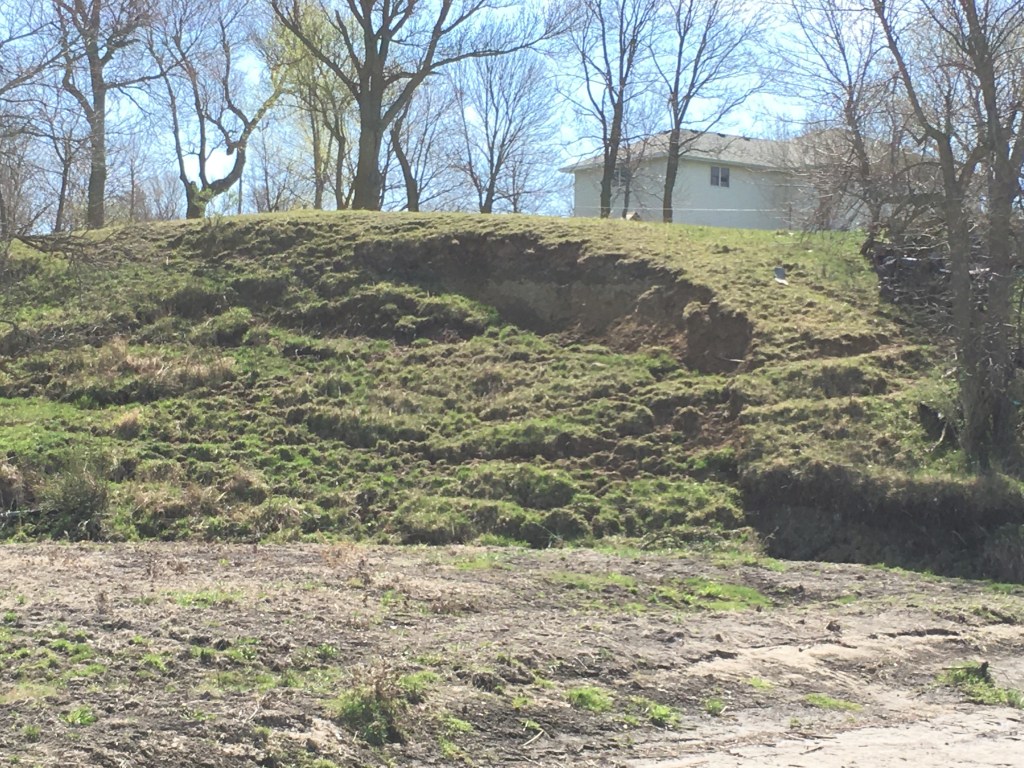
This perspective shows both landslides on the bluff behind our house. The oldest one is one the left and the newer one is below the line of pine trees up on the top of the hill. On the far right is the newest landslide that’s active this year. Now the shifting channel has activated another completely different area to the west along the bluff. So, the time sequence is 1-2-3 from east to west. The large tree and flat area between 2 and 3 probably influenced the location of the newest landslide. And, as the channel continues to shift and erode along the bluff there may well be another landslide area that forms farther west.
Over the past week, there’s been a video of a landslide along the Norwegian seacoast on Facebook. The first time I watched it, I thought that it was another animation of a rising sea level, but instead it’s a huge landslide block carrying houses away. Fortunately, no one was hurt, but it’s a dramatic real-time documentation of what has gone on in slow motion over the past several years on the bluff behind our house. Here’s the link to the Norwegian landslide. Unfortunately, I can’t get the Facebook link into this post, but you can find it by searching for: Ed Piotrowski WPDE massive mudslide.

Pingback: Fractured Clay as Aquifer | Lone Tree Farm on Kanaranzi Creek