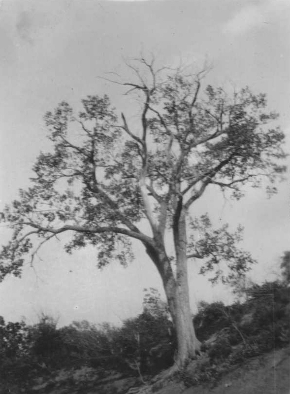
We think that this cottonwood tree is a descendent of the huge tree that gave Lone Tree Farm its name back in the 1870s. The original tree was just across the Creek to the left of this surviving tree. The old tree fell down in the 1930s and there was only a shared memory of its location when I was growing up in the 1950s. Things have changed a lot “down at the Creek” over all the years.
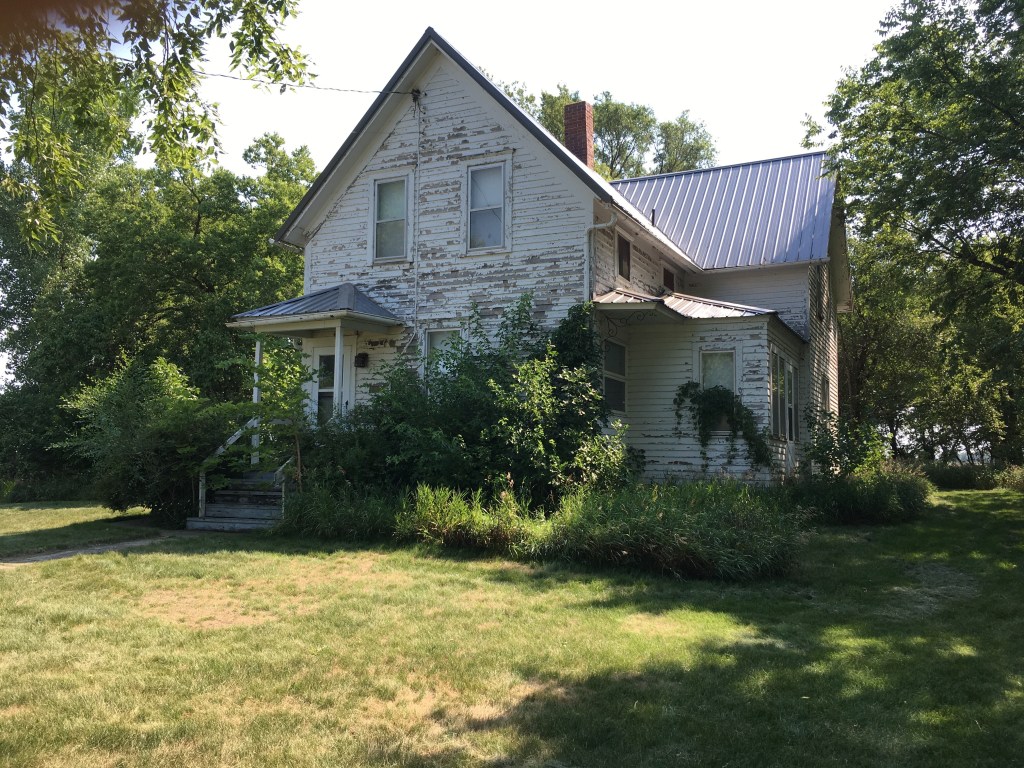
Changes have continued for us in the past few months. After the move to South Dakota last year, we’ve had a series of continuing changes….a new floor in the old house that’s “new” to us, I’ve got a new left knee (and the old right knee complains about it), and we just both tested negative for COVID after the quarantine cancelled a trip to Colorado!
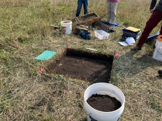
Changes continue on the Farm as well. Earlier this month a team of archaeologists did sampling and an excavation in the area where we’ve found lots of artifacts and buffalo bones. The photo above shows the excavation unit in the early stages of the digging; it ended up being several feet deep. The lab results aren’t all back yet, but it looks like there’s going to be some interesting stories coming out of the whole effort. Those stories will all “trickle” out in the new blog that I’ve just launched.
The new blog is actually a “newsletter” that’s not posted on Word Press, but will be available as an email. It’s called Land at the Edge of the Sky. Like this Lone Tree Farm on Kanaranzi Creek blog, the new newsletter/blog will tell stories related to rocks and water, plants and animals, and families and communities. So, the subject matter will be the same, but the area of focus will be out beyond the Farm.
The post is about a five-minute read and will probably be a little shorter than later stories. The plan is to do one or two posts a month, at least initially, and then increase the frequency as stories develop and readership increases. I anticipate that the first series, after the four introductory posts, will explore the possible connections between the archaeology on the Farm and the very significant complex of sites at the “Blood Run” National Historic Landmark just east of Sioux Falls.
Actually, this link is to only the second of four introductory posts. The first shares some aspirations for this new endeavor; the second is more of a preparation that describes the general area; the third will be explicitly naming the area of focus; and the last will explore some of the inspirations that are leading me to write about this Land at the Edge of the Sky. Please check them out and subscribe to see where this whole thing is going!
Every day, there are changes that happen hourly. Every season, there are changes that happen monthly. And every generation, there are changes that happen over the years. These daily, seasonal, and generational changes are inexorable and inescapable.
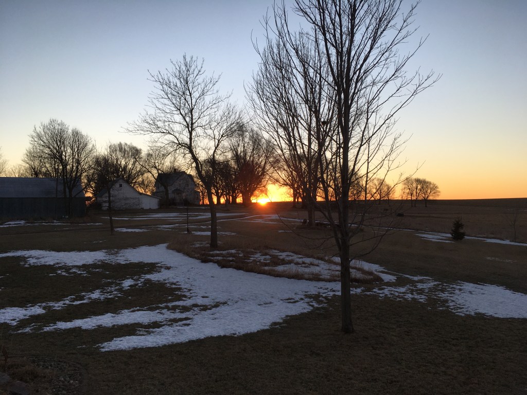
At sunrise on a clear day, the line of light brightens the tops of trees and then moves down the trunk to warm the ground. A breeze springs up and quickens in response to the differential heating along that light line. This picture was taken several weeks ago, but we could already clearly see the shift northward from the winter solstice position about a month ago. As the suns climbs higher in the sky during the day, this sunrise location shifts to the north headed for the spring season.
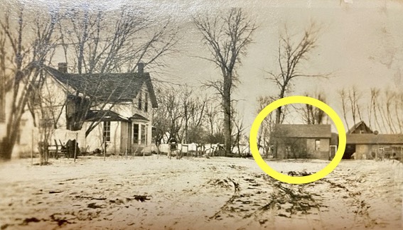
Grandma Daisy Walker Shurr used to say, “As the days grow longer, the cold grows stronger.” The hours of sunlight increase all through the cold winter months. But there are also changes all through the years from one generation to the next. Grandma Daisy was the daughter of homesteaders who lived just a few miles up the Kanaranzi Creek from our Lone Tree Farm. But old folks move off the farm and young families move onto the farm to raise a new brood of kids. This old photo has the original house of the homesteaders circled in yellow. It was repurposed as one of the outbuildings when a new family moved in. Ironically, my wife Margaret is a descendent of that second family. Thanks to one of her cousins who recently shared this picture.
The warm, moist breath of the mouse living in this house, has built a rim of frost around his door. During the cold winter season, his short-term changes leave a mark to outline this entrance at the end of the path. Short-term changes are one thing to deal with, but long-term changes can be a real challenge. A friend just recently told me that he remembers my Dad saying that change is hard enough for people who are forty and fifty years old, but people who are fifty and sixty years old really hate it.
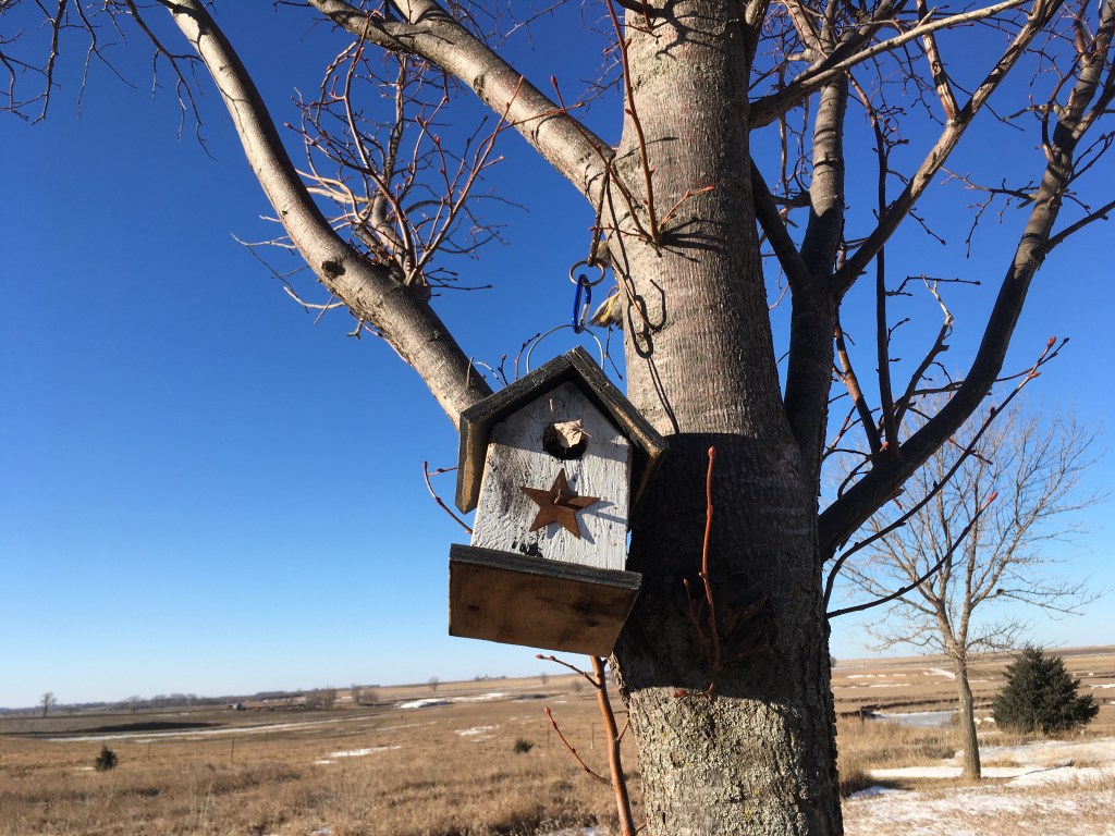
A couple of weeks ago, Margaret and I thought that we saw a bird at the door of this birdhouse. However, it turned out to be only a piece of last summer’s nest waving in the winter wind. The season controls what we see on a daily basis. Short-term changes are influenced by changes that happen over longer periods of time. Margaret has a favorite quote that says: “The only thing that’s constant is change.”
A friend who is a pilot took this photo earlier this fall. In this one picture you can see the homes of four generations. The old house in the background was built by the Shurr homesteaders. It was the house that Grandma Daisy moved into when she married the son of the homesteaders. And, it was the home for the homesteaders’ grandson and great-grandsons. The newer house in the foreground was built by Margaret and one of those great-grandsons….me. The homesteaders arrived at this place in 1871 and now, the neighborhood family who started renting our pasture in 1971, began the process of buying the new house in 2021.
So, the generational changes will be shifting from one family to another on Lone Tree Farm. Changes aren’t easy, but they can’t be avoided and they can be healthy. We’re fortunate that the new homeowners are also good farmers who are renting the land. They’ve shown a commitment to work with Mother Nature and do whatever is “good for the ground”. In that way, the original homesteaders’ legacy of letting the land help to decide what changes are needed, will continue.
A first Christmas is a significant thing: the first Christmas in a relationship; the first Christmas after a wedding; a baby’s first Christmas; the first Christmas after the death of a loved one. In 1871 our homesteading family celebrated their first Christmas in a new home. They had arrived in the area the previous year, but 150 years ago they were settled into the dugout for their first Christmas on Lone Tree Farm.
Great-grandma Hattie described the family and the dugout that sheltered them that first Christmas in letters that she wrote to sons who later moved to North Dakota as adults. John and Hattie had been married six years and had four children: Agnes who was 4 years old; Carl was 3; Lilly was 2; and baby Nettie had just been born in early November. After this first Christmas, four boys and one girl would be added to the family. The dugout was sort of a log cabin built into a hill. It had one big room about 15 by 25 feet that was lined with logs laid horizontally. There was a small, four-paned square window in the west side and the door was on the north end. The winter of 1871 was mild, so a carpet or blanket was hung as the door of the dugout. At first the floor was covered with hay, but with small children there was a fire danger so that had to change.
The homesteaders used a wild plum tree for that first Christmas in the dugout because there weren’t any evergreens available out on the prairie. In the winter, wild plum trees are pretty sparse and bare, so it probably took a lot of decorations to make the plum tree look as festive as when it had blossomed in the spring. When Great-grandpa John got supplies, he apparently also picked up mail from family and friends back East. And that’s how the family decorated the Christmas tree: they used bits of cotton and colored tissue paper saved from those packages. At that first Christmas in the dugout, gifts were put by the children’s plates at the table on Christmas morning. Those gifts must not have been very big.
A friend who is a pilot recently took this photo where the past and the present come together. We think that the dugout was located approximately at the red “X” and the red arrow points to where the Lone Tree probably stood. The tree was still standing in 1922 when the black and white picture was taken, but it fell down in the early 1930s. We built the big house in the middle ground more than 20 years ago. And, the farthest building is the house that the homesteading family built after those first Christmases in the dugout along the Creek. So, there are homes here for four generations of the family Christmas.
The homesteaders moved out of the dugout and into this house in 1874. The western part of the house was added on after Grandpa George and Grandma Daisy were married in 1904, so even the “new” part is almost 120 years old. My parents, John and Bernita, were married in 1940 and lived here for 70 Christmas seasons. Margaret and I moved back to the Farm in 1998 to add more celebrations to the string of Christmases. These days the poor old house is looking pretty tough. My parents left in about 2010 and since then it’s only been used to store artifacts and buffalo bones….and memories.
This Christmas in 2021 is the first Christmas in 150 years when there’s no family member living full time on the Farm. Margaret and I bought a second home in Vermillion, South Dakota, this year and we’ll be splitting our time between the two places for the near future. So, this is also the first Christmas in our new home.
The Kanaranzi Creek has memories to share. When the water is high in flood, clues to those memories erode out of the high banks and are deposited on the adjacent downstream sand bars. And, the trophy hunters who find these treasures get concrete insights into the deep history that the Creek remembers. For example, it looks like Native Americans have been traveling through this valley for thousands of years. However, the folks who find the artifacts and bones need help from other people to convert those clues into stories.
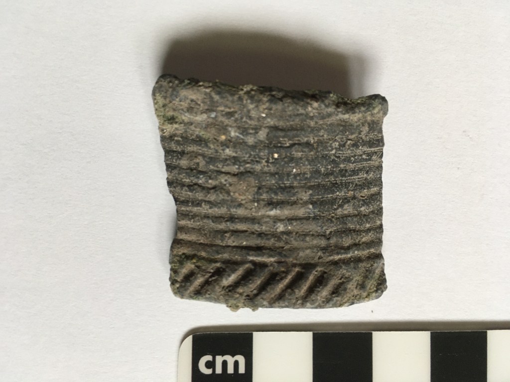
This is the second piece of pottery (a.k.a. sherd) that has turned up on a sandbar after flooding. Like the first one, an archaeologist has identified the pattern as associated with a specific Native American cultural group known as the Great Oasis. What’s more, he thinks that the pieces came from two separate pots. The people who made this pottery mostly lived in northwestern Iowa about a thousand years ago, but must have at least traveled along the Creek valley and left behind these clues. Another archaeologist interpreted an arrowhead–one of about a dozen found along the Creek– to be an Archaic form which means that it could go back as much as ten thousand years. Plus, we know that Dakota families moved along the Creek a little more than one hundred years ago because the homesteaders saw them and talked to them. That means that this stretch of the stream is a “multicomponent site” with a record of several different Native American groups that goes back for hundreds to thousands of years.
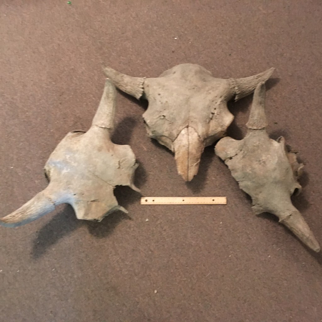
The Native Americans were probably hunting buffalo (technically known as bison) in the valley. The Creek has also shared this part of the story because these three skulls washed out during high water. A paleobiologist told us that they aren’t primitive Ice Age animals, but are probably the newer species that would be available for Native American hunters. However, these weren’t all just transitory hunting parties following buffalo along the Creek corridor because there are also some primitive corn cobs that have eroded out of the banks. That suggests that some of those people actually stopped and raised crops along this route. In fact, an archaeologist who did geophysical measurements on a circular vegetation anomaly has suggested that there may have been the remains of a dwelling in this multicomponent site. She thinks that it was probably built by the Great Oasis people because of the pieces of pottery.
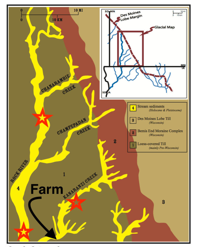
The Kanaranzi is only one of a series of streams that were used as travel corridors by Native Americans. Some of those travelers were from the tall grass prairie with big rivers to the south, but they were challenged by the Dakota who dominated the country of lakes and forests to the north. The three red stars mark places where settlers documented incidents between these travelers from the south and the Dakota people. A battle along the Rock River between the Dakota and Ponca people is described in an early history of Rock County. Farther south along the Rock River our homesteading great-grandparents encountered a Winnebago man who had trailed a wounded elk up from his reservation in the south; he was nervous about the Dakota catching him this far north. And the third incident was a battle between the Dakota and a group of southern people known as the Kansa. It’s described in a history of the nearby town of Ellsworth. That fight may have taken place a few miles north of the Farm and is memorialized in name of the Creek. “Kanaranzi” means “place where the Kansa were killed” in the Dakota language. These three encounters recorded in white history records are probably not the only ones that happened along the streams that flow out of the north and east. The Kanaranzi Creek and Rock River are not the only drainages that have memories of conflict along the corridors. All of these valleys (Unit 4) were originally formed when water coming off a melting glacier (the Des Moines lobe, Units 2 and 3) located just to the north and east, spilled out onto a broad plain of older glacial material (Unit 1).
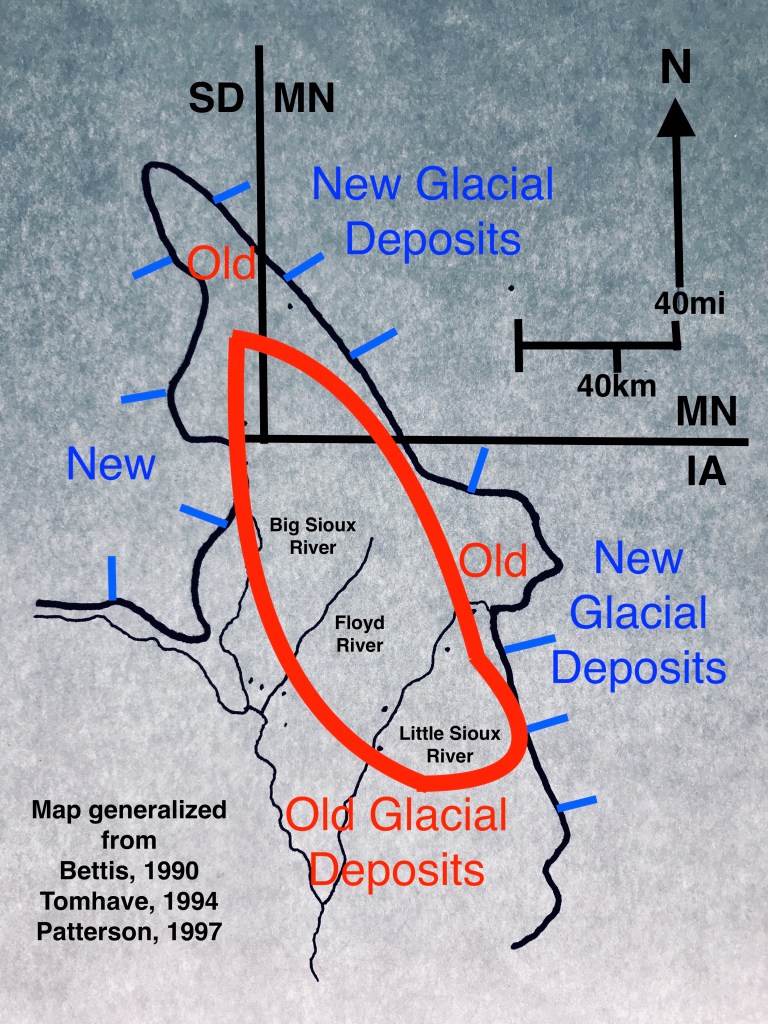
The drainages that form corridors near the Farm are only part of a larger network of old meltwater valleys spread across the transition zone between the new and older glacial deposits. Main stem rivers like the Big Sioux and Little Sioux also provided travel corridors that crossed the borderlands between north and south core areas. The area of newer glacial material has been recognized as a distinctive resource area by a former state archaeologist for Minnesota. He has called it the “Prairie Lakes” region and characterized the various Native American cultures that lived there. Those cultures, like the Dakota, that used the lakes and forests were very different than the cultures, like the Ponca and Kansa, that developed to the south where big rivers and tallgrass prairies were dominant. In fact, those cultural differences and the territories they routinely occupied were probably a root cause of the conflicts documented by the settlers in the corridors near the Farm.
So, the Kanaranzi Creek and the other streams all carry memories of a lot of human activity. The northern core region of forests and lakes in the areas of new glacial deposits and the southern core region of tallgrass and big rivers in the area of old glacial deposits were connected by a network of travel corridors used by Native Americans. In addition, these same landscapes influenced the subsequent development of transportation and commerce in the cultures of later white settlers.
This post uses a number of sources that are only partially acknowledged. If you’d like the complete detailed formal references, please let me know in the comments below (with your email address for a response).
The traditional views of the origins of Thanksgiving involve Indians and Pilgrims sharing a meal to celebrate peaceful coexistence and the Fall harvest. In reality, the Indigenous people probably saved the colonial settlers from starvation and later interactions were hardly peaceful. In contrast, our homesteading great-grandparents and grandparents had a completely different experience along the Kanaranzi Creek in the early 1870s.
Our family lived in a shelter dug into the side of a hill for several years before moving into the farmhouse. This “dugout” was located along the Creek very near the lone cottonwood tree that gave the farm its name. In those early years, it was fairly common for family groups of Dakota (a.k.a. “Sioux”) people to travel along the Creek valley using it as a corridor through the tall grass prairie. The encounters between our homesteading family and the traveling Dakota families were very friendly and amiable. One of our family stories tells about a Dakota man who stopped at the dugout and asked Great-grandma Hattie to sharpen his knife on the grindstone. I don’t know if this is the exact grindstone, but it’s an old one that that’s been around the farm for more than a hundred years. Another family story says that the Dakota people would have Great-grandpa John buy supplies so the traders wouldn’t cheat them.
But it wasn’t just Native Americans who used the Creek valley as a travel corridor. Early white trappers and homesteaders tended to follow stream valleys as well. The yellow lines on this map show trails used by white people around the time of the Civil War. One is an overland mail route, but the north-south trail follows the Rock River and eventually a railroad and later a federal highway followed that same route. Lone Tree Farm is designated with a red star and there’s no trail shown along Kanaranzi Creek. But after the Civil War, homesteaders (including veterans marked by yellow boxes) tended to settle along the drainages first. The colored dots document the pattern of early homesteads concentrated along drainages: red dots are parcels filed in the 1870s, blue dots are the 1880s, and green dots are the 1890s. For some unknown reason, Grandpa John didn’t formally file his claim until the 1880s, so there’s a blue dot inside the red star. But, the 1870s red dots are clearly clustered along the corridors provided by streams including the Kanaranzi Creek.
This club is literally from Grandma Daisy’s attic. The family tradition was that it’s some sort of souvenir, maybe from one of the “Wild West’ shows that were such a big deal in the early 1900s. In any case it’s not an authentic Native American trophy because when I showed it to Dakota-speaking friends, they pointed out that stone head should be more tightly bound to the handle. It’s a fake, just like the Hollywood stereotypes of marauding warriors terrorizing the white settlers. Our reality along the Kanaranzi Creek corridor was that most of the interactions with the traveling Dakota families involved children. One of our family stories tells about a Dakota woman who was really impressed with the fair, light-colored hair of the Shurr kids. Another story says that the homestead kids would routinely visit the camps of the Dakota traveling through the valley. But, sometimes they apparently over-stayed their welcome. A white trapper who was part of one of the Native American groups told the kids to go back home or they’d end up in the cooking pot!
This painting of the Lone Tree was done by Great-grandma Hattie. The view is across the Creek to the south from the flat part of the floodplain where the Dakota families used to set up their camp. The smaller trees in the right side of the picture are probably plum trees; there’s still an extensive thicket of wild plums near this location. So this is what the tree looked like when the homestead kids visited the travelers. And, this is the view that the Native Americans and the homesteaders shared when they got together for a visit and for a meal. We’re pretty certain that the two groups enjoyed food together because there’s a quote that our family tradition relates to these exchanges: “Dig deep. The meat is on the bottom of the kettle.” Cooking kettles and families and harmony were all hallmarks of the movement of people along the Kanaranzi Creek corridor. Happy Thanksgiving.
Stream valleys like the one that the Kanaranzi Creek occupies, provide natural corridors for the migration and movement of wildlife. The surrounding uplands are all planted in monoculture row-crops, so the pastures along the stream channels have diverse environmental mosaics that provide cover and are helpful as “stepping stones” for travel. However, the stream valleys also provide roadmaps to guide the long-distance fly-over birds, as well as the local birds that migrate away to the south for the winter. Down in the water and along the floodplain, there are also other animals that follow these corridor routes throughout the year.
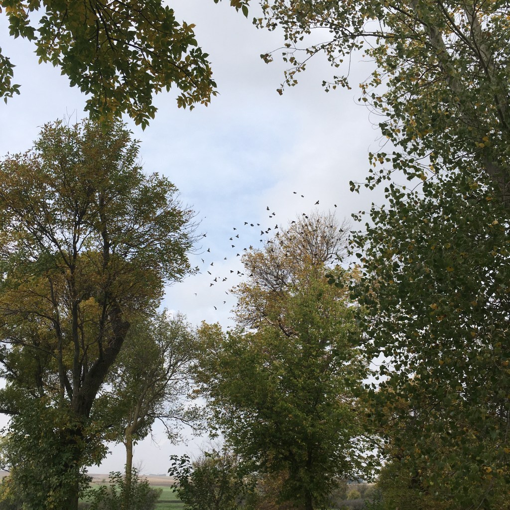
The blackbirds have been around all Spring and Summer, but now in the Fall they gather in large and noisy flocks getting ready for the long fly south. They hang around in bunches while there are still leaves on the trees, but by the time the trees are bare the blackbirds are gone. In contrast, the eagles and vultures seem to be here year-round. These guys are scavengers. So as long as there’s dead meat available (like the piles waiting for the rendering truck outside hog barns) they don’t need to “migrate” very far….maybe a few miles up the Creek and back down to the Rock River.
One of the early signs of Fall are the geese that follow the Creek. Actually, it’s only the smaller family units that fly up the Creek in the morning and then return back downstream in the late afternoon. I think that they spend the night down along the Rock River and then return up the Creek valley for breakfast and lunch. In contrast, the long-distance fliers are big bunches that fly so high up that it’s hard to pick out individual birds and the flights look like thin strings against the blue sky. But, even at those heights, you can hear them calling encouragement to each other as they shift trading places to become the lead bird.
The U.S. Fish and Wildlife Service has identified a number of big river valleys in Iowa as corridors where migrating birds may encounter structures that pose collision hazards. These large streams are north-to-south thoroughfares used by both the long-distance fliers and the shifts of more local populations. In effect, the stream valleys are part of the connections between core areas of Summer residency in the north to the Winter retreats in the south. This “connectivity” is even more important for the animals that swim in the stream channels or walk along the floodplains.
This little guy caused a lot of excitement a few years back when cricket frogs were first identified in the oxbow wetland that occupies an abandoned channel meander in our pasture. They are listed as endangered species in Minnesota. Apparently they migrated up the Creek from the Rock River in Iowa and had not been documented in Minnesota for several decades. The Creek was a corridor that provided access to Minnesota, even though the site is only about a quarter mile from Iowa. Unfortunately, the drought early in the summer dried up the wetland and we didn’t see or hear any cricket frogs singing this year. Fortunately, we’ve not had any invasive species like flying carp or zebra mussels migrate up the channel in this wildlife corridor!
Several years ago, a neighbor found this paw print beside the Rock River a couple miles west of the Farm along the Stateline. Mountain lion sightings always cause a lot of excitement in the area because people are concerned about livestock. But, like coyotes, these peak predators are more interested in thinning the deer herds in the stream valleys, than killing domestic animals. Both mountain lions and coyotes tend to move along the corridors provided by big rivers and probably cover a lot of miles in their travels. There recently was a moose sighted in our area and although only one of the sightings was along a stream, that was probably his main route because people wouldn’t see him in the trees and brush that provide protection down on the stream’s floodplain.
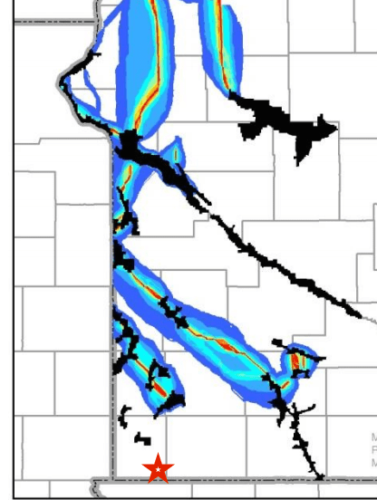
The Nature Conservancy in conjunction with a number of Minnesota state agencies and nonprofit groups has mapped possible corridors (shown as colored bands) that might connect existing “core areas” (the small black squiggles) where there are viable prairie acreages. The big Minnesota River valley is the long black line trending southeast through the middle of the map, but the colored corridors in the southwest corner aren’t stream valleys. They’re glacial end moraine complexes that are too rocky and have rolling topography not conducive to farming. These southeast-trending corridors are connecting small patches of preserved prairie, rather than the huge core areas connected by big river valleys for migrating birds. However, valleys formed by streams of water flowing southwest off the front of the melting glaciers also form corridors. The Rock River and its tributaries fit that description. That includes the Kanaranzi Creek where it flows through Lone Tree Farm shown by the red star.
This post is the first in a transition series that will provide an introduction to a new venture. I’m planning to do a different blog that will continue the stories about the natural science and human history around Lone Tree Farm. But, the area will be expanded to include multi-county parts of southwestern Minnesota, northwestern Iowa, and adjacent stretches of eastern South Dakota. If you have any reactions to this idea, please share them in the comments section at the bottom of this page.
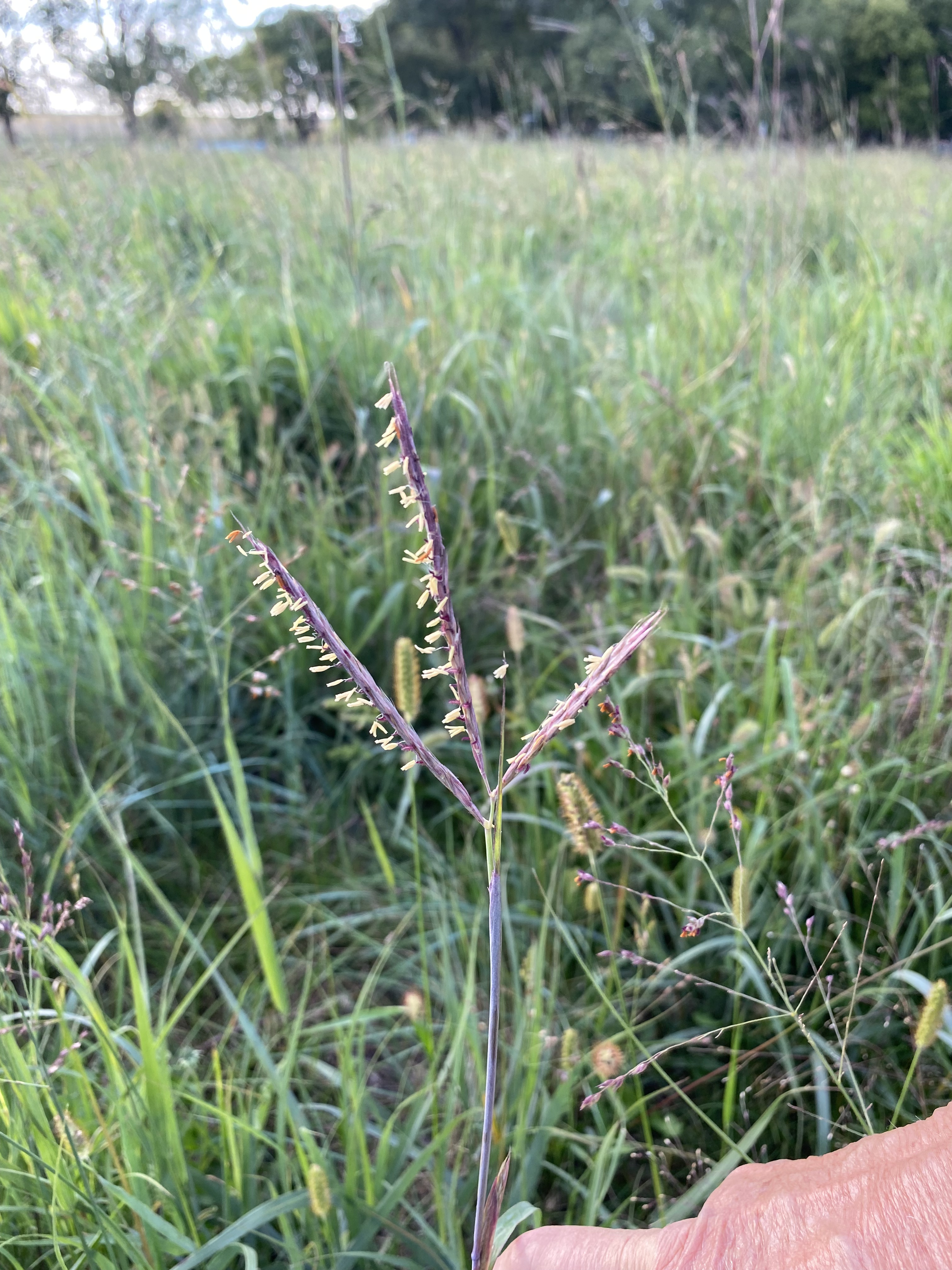
This is the season when many native prairie grasses take on a red or purple color along the stems and out onto the leaves. There are several species that turn red, but big bluestem and little bluestem are two of the most distinctive and two of the native grasses that we have on the Farm.
We’ve got at least four areas around the Farm where we’ve identified native prairie grasses. These two shots are of big bluestem in one of the three warm season paddocks located just to the east of the farmyard. This paddock has maintained a pretty good stand of big bluestem and several other native species. However, compared to last year, the other two paddocks have lost ground as the ubiquitous brome invades.
Dad always called big blue stem “turkey foot” because the seed head has that shape. The photo on the left illustrates the distinctive pattern and also shows yellow pollen clinging to the grass head that’s colored red. The photo on the right shows some other yellow colors in the warm season paddocks. There are several clumps of sunflowers that add to both the biodiversity and the esthetics, even if they’re not particularly good for grazing.
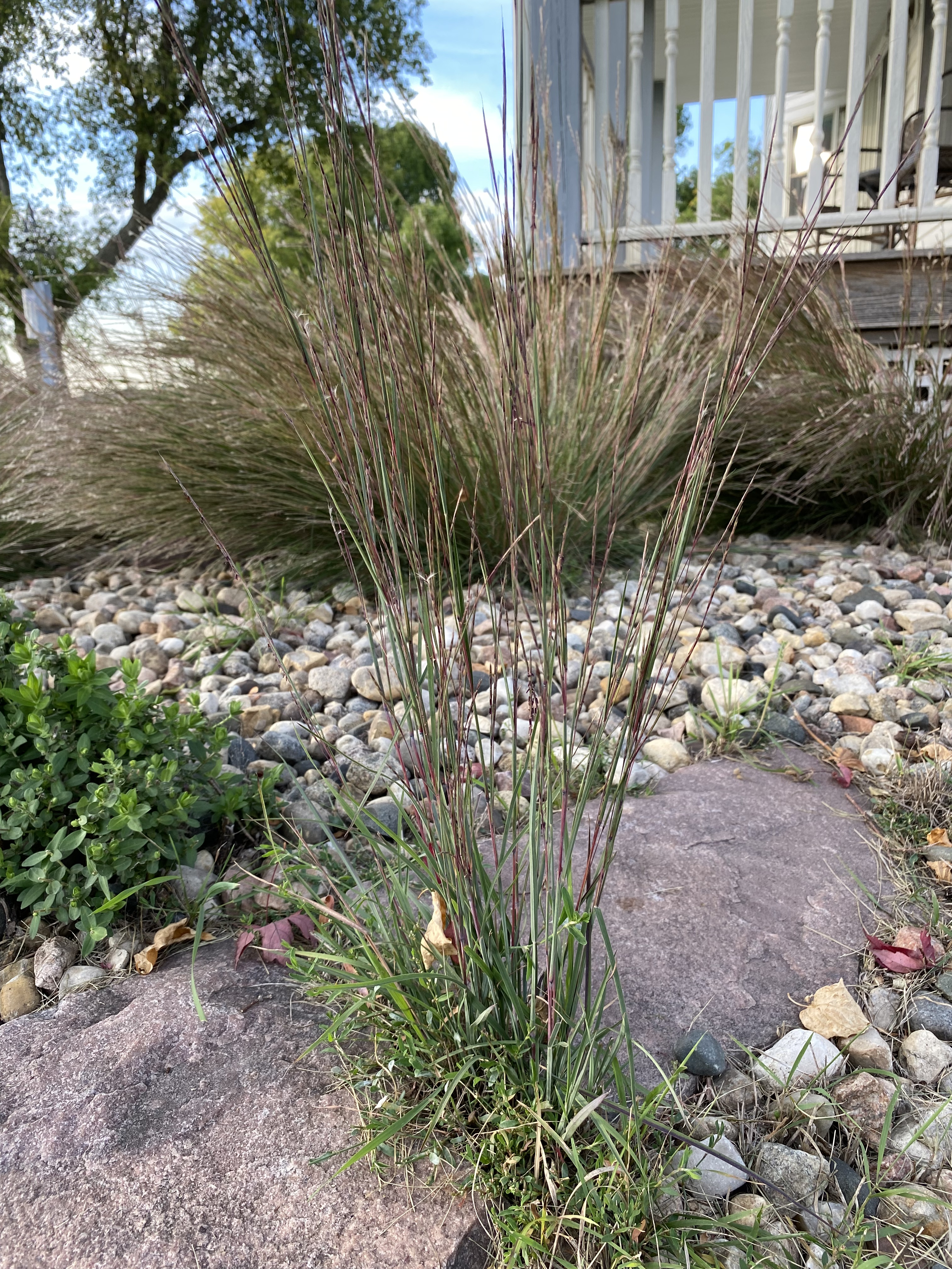
The area of big bluestem located just to the house of our house also did not do well this year. We had hoped that the stand of native grass would grow larger, but again the brome was a successful competitor and limited expansion. On the other hand, the little bluestem that’s part of the landscaping right next to the house did very well. It even expanded out into the area between the rocks that are located back away from the bunches of grass that we planted.
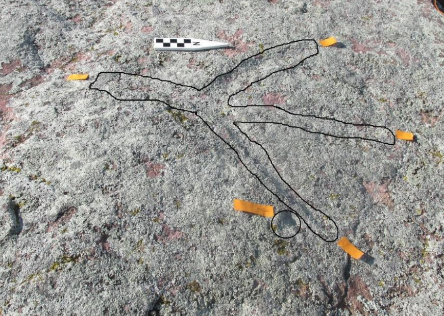
So, what does big bluestem have to do with Native American rock art? There’s a fairly common and distinctive motif that’s called a “turkey track”. The first image is an example on Pilot Rock near Cherokee in northwest Iowa (from a thesis by Quinn Black—complete reference available on request). This is fairly subtle rock art that is outlined for easy identification. But, there are also many examples at the petroglyph site near Jeffers in southwestern Minnesota. The image on the right is taken from a professional archaeology publication (again, the complete reference is available on request) describing a site in southeastern South Dakota. The intent is to demonstrate that the turkey track motif shown on the pottery fragment in the lower right, closely resembles the seed head of big bluestem grass. The “turkey track” motif in Native American rock art is very much like Dad’s “turkey foot” name for big bluestem.
And finally, since the season of the red grass is late summer and early fall, here are a couple of Margaret’s photos from yesterday….the last day of summer. The setting moon is from the early morning and the evening sunset is directly over the east-west Stateline. All of the photos in this post are hers. They always add an important dimension to this blog and I’m grateful for her help.
When the homesteaders came to the Farm, the Civil War had been over for about six years. Although there was no direct involvement by family members who lived here on the Farm, one of the sons (Grandpa George) married the daughter (Grandma Daisy) of a Civil War veteran who had homesteaded a few miles up the Creek. He was part of a group of veterans living near each other along Kanaranzi Creek.
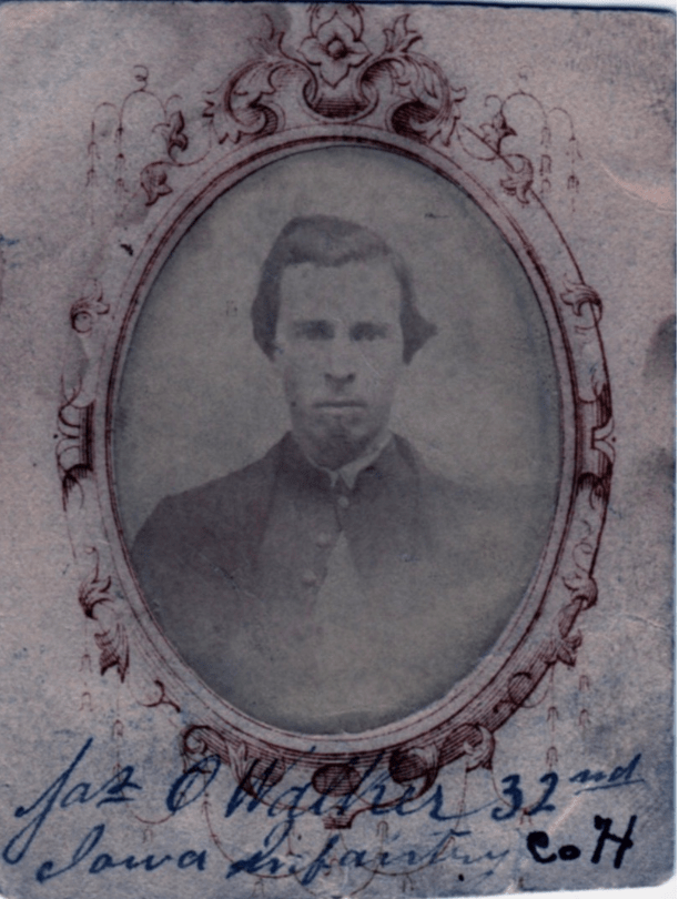
James O. Walker took a soldier’s homestead claim in the spring of 1871, which was the same year that his future son-in-law’s family homesteaded farther south along the Creek. His sister and her husband were also part of the cluster of Civil War veterans who settled in the same neighborhood. Biographies for both men are included in an unpublished manuscript written by Ray Crippen available in the files of the Nobles County Historical Society. Crippen includes some political details about Great-grandpa Walker that are not a part of our family tradition. Walker served one term as county auditor in the late 1870s at a time of confusion and division among Republicans. The veterans’ organization called the Grand Army of the Republic (G.A.R.) dominated county politics and also played a significant role at the national level.
The Walkers left the farm and moved to town in 1888. That was the year that historians tell us the tumultuous presidential election hinged on the admission of new states, including nearby South Dakota. The power shifted from the Democrats to the Republicans and James Walker was appointed as the postmaster of Ellsworth in 1889. Although we can’t be certain, his appointment may have been related to being a Civil War veteran and role that the G.A.R. played in politics. The politics in that election stretched all the way back to the Civil War and the struggles with Reconstruction after it. Ironically, our family stories about him don’t mention his involvement with the G.A.R., but then we never knew about his term as county auditor until reading about it in the Crippen manuscript.
James Walker was born in county Donegal, Ireland in 1838. The Walkers had moved from Scotland to Northern Ireland in the 1700s in what was probably part of the English plantation system. This photo shows the driveway up to the Walker farmstead near Corkermore when we visited there in 2012. Unfortunately, the cousin living there was hospitalized at the time so we never talked to him. We did, however, find lots of Walker relatives in several cemeteries. That included the family of Mary Walker, James’ wife. Although she had the same last name, her family were fishermen down on the coast of the Donegal peninsula while James came from farmers who lived farther inland. Mary had a very sad and complicated life. Her first husband died at sea when they were immigrating to America. She returned to Ireland for several years, but then immigrated again. James and Mary were married in Hampton, Iowa, in 1870 five years after James returned from the Civil War. My Dad remembers his Grandma Walker as a sad and somewhat bitter old lady. However, my aunt enjoyed her company more than her more severe Grandma Hattie Shurr. Kids who are different ages have different memories. Although Mary was some thirteen years younger than James, she died in 1927, several years before he did.
James immigrated to the Unites States in 1860 and in 1862 he enlisted in the 32nd Iowa Infantry at the age of 24. We don’t know for sure that he was paid to join in place of another man, but that possibility was part of our family tradition and it was apparently a fairly common practice early in the war. The story goes that because he had very good handwriting, he was given courier duties. That suggests that he may have had some interesting experiences, but the family never heard much about any wartime adventures. In any case, his involvement with the G.A.R. was minimal, except perhaps during the election for county auditor. We don’t have any family stories about his direct participation in G.A.R. activities. That matches the impression of the descendant of another Civil War veteran in the county who shared that her great-grandfather “just didn’t care for all the fuss made about the Civil War”. My Dad always said that any of his friends who saw a lot of action in World War II never discussed them much. The men most enthusiastic about veterans’ organizations generally had pretty low-key experiences and that was probably true for the Grand Army of the Republic as well.
But, the G.A.R. was a busy organization. It’s possible that the posse that chased Jesse and Frank James through the county after the Northfield bank robbery in 1876 included a lot of Civil War veterans. Ray Crippen’s manuscript has the following quote: “It is today questionable whether any portion of the United States has an equal portion of veterans of the war among its inhabitant as has Southwestern Minnesota.” The Confederates’ “guerilla attack” in southern Minnesota turned out the Union boys in blue to meet the challenge. The James boys escape through this area is part of another of our family traditions related to the Civil War.
The story goes that several of the older boys were plowing and saw two riders in the distance who they thought might be the James brothers. So the Shurr brothers unhitched the team and mounted up to give chase. These guys would have been teenagers and probably didn’t have any guns as they headed out on a couple of old plow horses. The exciting climax to the family story says that the two strangers rode away, but fired over their shoulders at the pursing farm boys. One of the bullets supposedly lodged in a horse collar and the Shurr brothers gave up on the chase. Unfortunately, the horse collar with the bullet has been misplaced over the years and that has caused some family members to question the whole episode. It does make a good story though!
There is another Civil War connection to Lone Tree Farm, however, that carries more serious implications. This land was once part of the homeland for the Dakota people. During the Civil War in 1862, the Dakota-US War provided an excuse for the removal of the Dakota Nation (and other Native Americans) from a wide area of the upper Midwest. That included the land homesteaded a few years later by the Shurr family.
James Walker spent the last few years of his life moving between his daughters’ homes in Sioux City, Iowa, and the Lone Tree Farm. He loved the poems by Bobby Burns; his grandchildren gave this book to him in 1921. Our Civil War veteran died in 1930 in the farmhouse built by the homesteaders where three more generations of the Shurr family subsequently lived.
The water level in the Creek after the rain last week was about 1 foot higher than a couple of days before that and 2 feet higher than several weeks ago. It hasn’t been this high since the spring of 2020. But, it’s still not at the same level as the prolonged high water during the record wet years of 2018 and 2019.
The flood last week did impact the electric fences that cross the channel. Although the water is slowly dropping this week, it’s still pretty high. The drought index has improved a lot in our immediate area. However, that doesn’t mean that the drought is “over”. Things will continue to change. And, one of the things that changes is the view of a big boulder in the main Creek channel.
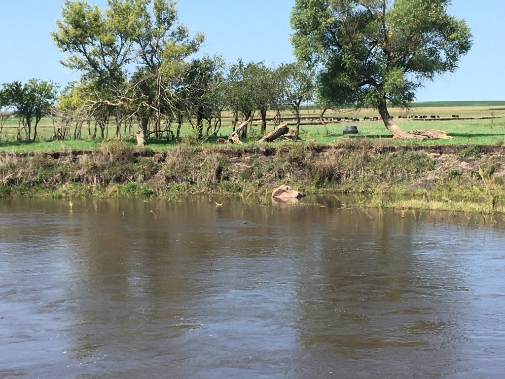
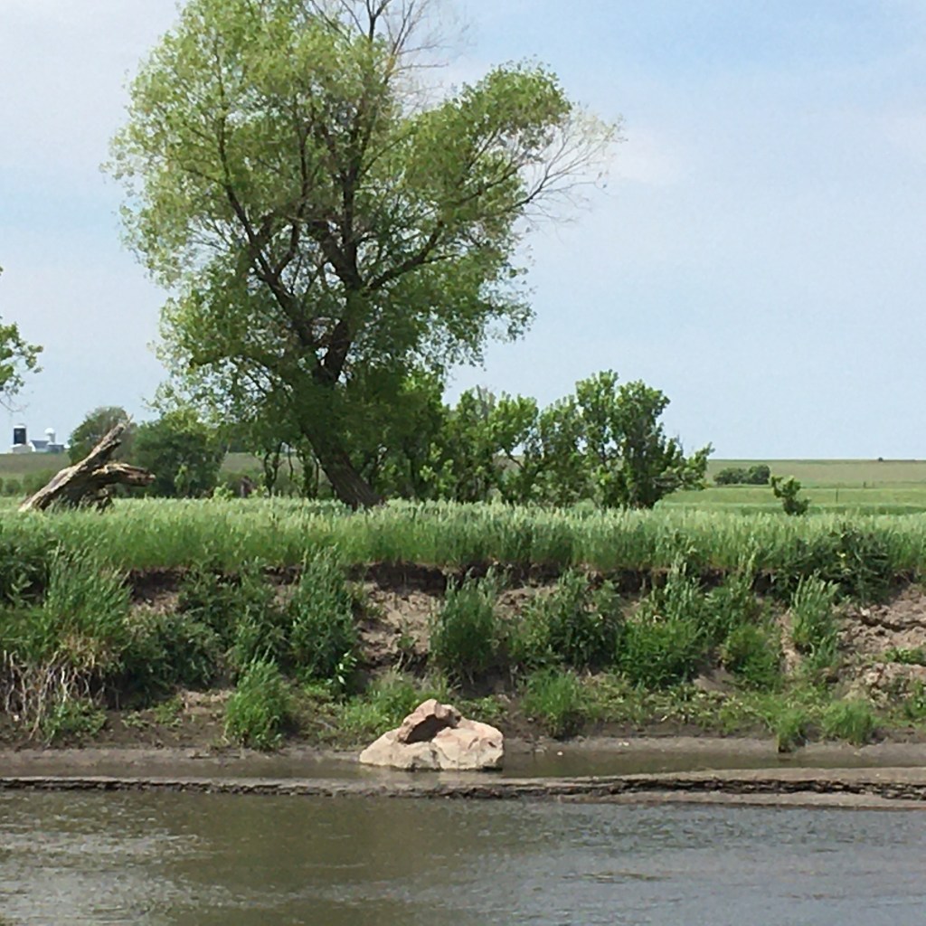
This is what the high water looked like last week. Earlier this summer the rock hid in tall green grass that was growing in front of it. But, the grazing took down that grass cover so the rock was visible again. Then the rains hit and the Creek rose, but it didn’t cover the boulder. The closer shot on the right was taken yesterday. The high-water line is marked by the top of the white area, which is probably scum left by the flood. Also, there’s a distinctive knob on the top of the rock that we’ll see again in earlier photos when the Creek bank was much closer to the boulder.
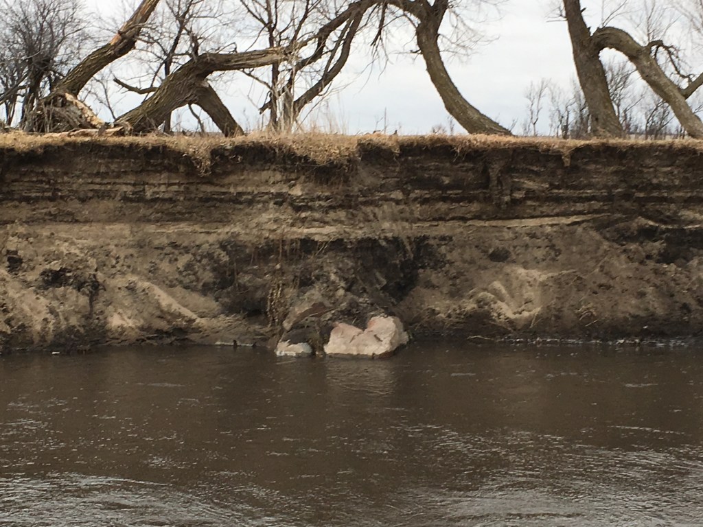
This is what the rock looked like last year. You can really see that distinctive top and the high channel bank behind it has some vegetation, even though there’s no grass in front of the rock like there was this year. There’s a pretty wide gap between the top of the rock and the edge of the bank. The 2019 photo on the right is taken from a different angle to show where the rock is relative to the high bank. The gap is smaller and the bank is closer. But not too many years before that, the rock was completely hidden because the whole thing was buried in the bank. The years of high water have totally exposed the rock that hides.
In 2017 the bank was close enough so that soil slumping off the steep slope could partially cover the rock. Gravity was doing its job. The 2016 photo on the right shows the rock only barely immerging from the dirt. You can’t see the distinctive knob on top at all. It’s hard for the rock to stay hidden because everything is dynamic. The grass grows but then is grazed down. The water levels come up but then drop back down. Even the dirt in the channel bank seems to conspire to expose the rock that tries to hide. The channel bank erosion described in a post last summer makes it look like the rock is moving. But, it’s just hiding and everything else is moving.
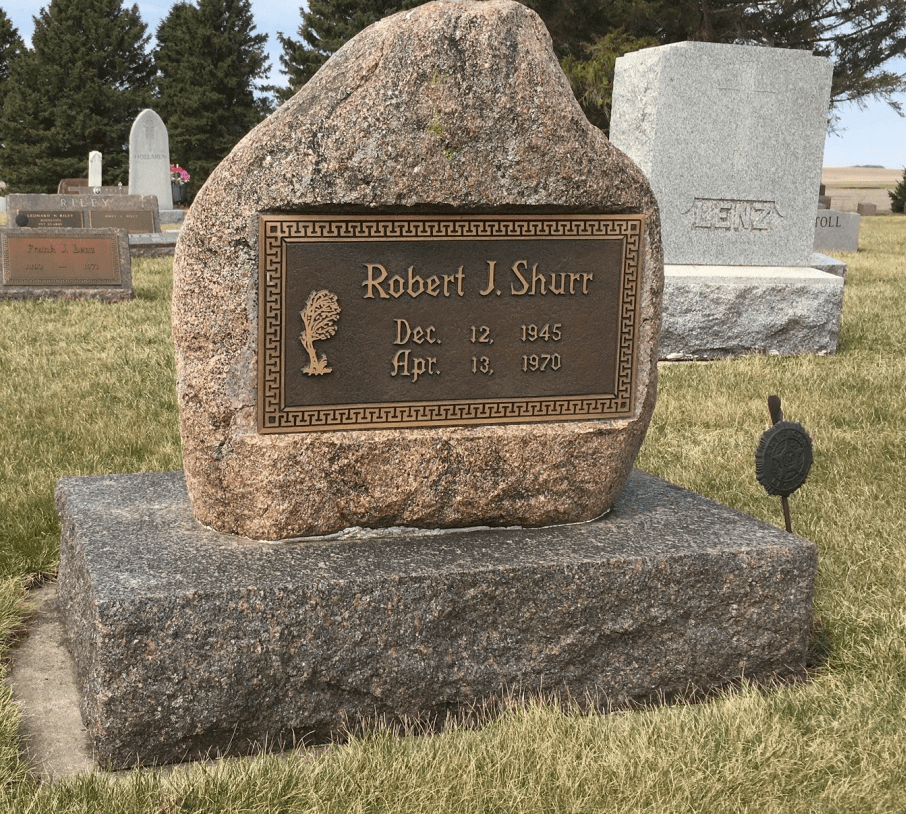
In addition to the rock that hides, there are rocks along the Creek that actually do move. During spring floods ice rafts will carry boulders from upstream. They probably erode out of a high bank and drop onto the ice raft to take a ride. Then when the ice melts the rock is left in a new location. That’s most likely the story for the rock on the left; the white object on it is a jackknife for scale. The rock that hides is located near where we found the boulder that became Brother Bob’s headstone. It’s another example of a rock that moved.
There’s also another rock hiding in the stream sediments just around the bend from the one described in this post. The location is close to where we think the homesteaders’ dugout was located. It’s not visible these days, but I remember that it wasn’t hiding in 1970. There are some old photos showing it back in the 1940s, I think. Someday that hidden rock will reemerge as the channel erodes over to that rock’s hiding place.
The first four generations of our farming history were reviewed in a post back in July, but this current one will concentrate on just the last two generations. The “environment” was not really a factor in the subsistence farming done by the early homesteaders; they were just trying to survive. And, it wasn’t a very important aspect of the bonanza farming done by the children of the homesteaders in the next generation; they were busy trying to make money.
During the next two generations (running from about 1940 to 2020), there was a growing awareness about the significance of environmental concerns on our farm. Out in the wider world, two stereotypes of farming were emerging. Commodity agriculture is generally associated with corporations running huge, extractive operations that usually make good money, but also are hard on the environment and disruptive for existing farm neighborhoods. Organic farming is an alternative approach visualized as small farms that are only marginally economic, but have minimal environmental impacts and tend to foster local communities. However, there is also an emerging middle way that’s being called “sustainable agriculture”. Nether of the two stereotypes applies directly to our farm or to those around us, but sustainable agriculture may be a useful business model.
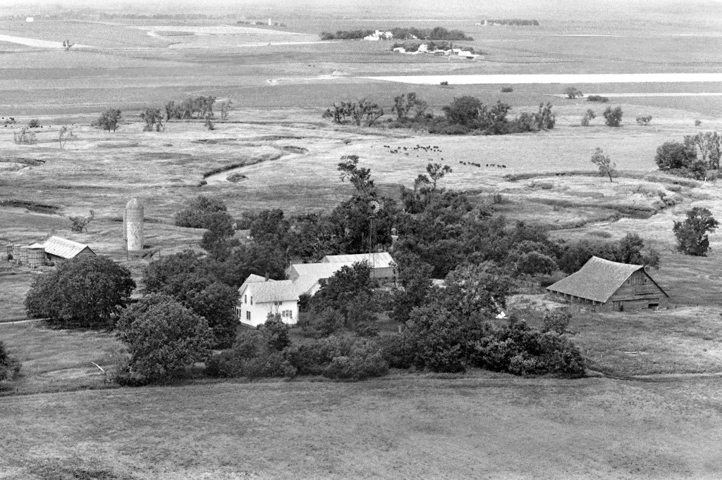
1978 air photo
About half of our farm has uplands of wind-blown silt covering glacial deposits. This ground is well suited for row crops, mainly corn and beans. The other half of the farm is on the flat floodplain of stream deposits along Kanaranzi Creek. This pastureland has had a tendency to flood, so row crops don’t do so well. But, it’s great for grazing; in fact you can see a bunch of cattle in the middle ground of this photo, which is a view to the northwest. The first farm visible in the background is no longer there and that whole farmyard has now been converted to row-crop. Many of the structures in our farmyard have also been removed (like the barn, windmill, silo and shed near the corn cribs).
Between about 1940 and 1980, a lot of the technical advice came from state and federal agencies. For example, we have a document that is a five-year crop rotation plan dated 1945. It came from the US Department of Agriculture, specifically the Soil Conservation Service (now called the Natural Resources Conservation Service, a.k.a. NRCS). In the late 1940s, Dad also participated in a federal program to grow seed for brome grass. In those days brome was touted as an important tool in soil conservation because the extensive root system cuts down on erosion. Ironically, now the folks involved in prairie reconstruction hate brome as a non-native, invasive species. Best management practices may change over time, but brome is still great forage in our creek pasture.
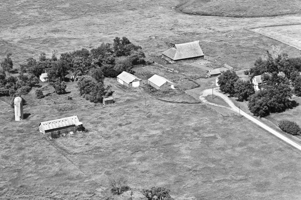
1983 air photo
This view to the northeast shows the farmyard buildings more clearly. The pens around the two metal sheds are left over from the time when my brother and I raised sheep. The transition from one generation to the next was complicated when Bob was killed in action in Viet Nam. By the time that this photo was taken, Dad was beginning to relay more on younger neighbors as renters. Those renters did do some innovative things like minimum tillage and rotational grazing. But, the state and federal agencies progressively provided less technical help and emphasized more programs for direct payments that encouraged row-crop development over grassland pastures. At the same time, a lot of the technical information on agrochemicals and genetics was coming directly from the companies that produced the products.
2010 air photo
In this view to the northeast, you can again see cattle out in paddocks designed for rotational grazing and off in the upper right corner there are two fields of row crops set up for two-year rotation. The farmyard has been simplified with the removal of more old buildings; our new house, which was built about ten years earlier, has been added to the picture. By this time most of the technical information was provided to operators by “agronomists” who worked for the large agribusiness corporations that made fertilizers, pesticides, herbicides, and pharmaceuticals. However, there was an emerging alternative source of information. Nonprofit organizations began advocating for sustainable agricultural practices and several small companies were busy with educating operators about alternatives to the prevailing business model of commodity agriculture. The alternative approaches emphasize profit over production and incorporate environment concerns into the best management practices. The “recipe” for this alternative, sustainable agriculture model could be summarized as cash, conservation, and community. A farming operation must be economically viable, must have minimal adverse effects on the environment, and must foster healthy rural communities. This set of three characteristics is basically the same as the three mandates employed by urban “B-corporations”: profit, planet, and people. Wikipedia describes these b-corps as companies certified for responsible environmental and social performance.
2017 air photo
This most recent view back to the northwest shows basically the same farmyard setup, but there are some more subtle changes. In the lower right corner you can see two of the paddocks seeded to warm season grasses and the black dirt “road” marks the route of the pipeline that now brings in rural water for the cattle. So, these changes are moving the operation in the direction of a “grass farm”. In the last couple of years, sustainable agriculture has picked up some new emphasis and undergone some clear shifts in meaning. Cover crops and soil health have been part of our operation for several years, but now sustainable ag, seems to be morphing into something new called ”regenerative agriculture”.
During the COVID year of 2020, two companies in particular have pushed the idea of regenerative ag. They’re basically responding to a perceived market demand for products beyond just organic. One company kicked off a social media campaign with a documentary that featured some of the original people who encouraged sustainable ag. However, that company is now mainly emphasizing advocacy and education; there’s not many specifics for our farm. The second company includes old-guard environmental nonprofits and big multinational food corporations. They’re trying to develop a certification process that will lead to marketing environmental services credits similar to the more established carbon credits. It’s an interesting concept, but their initial demonstration farms aren’t near us. And, they don’t have anything developed yet that we can incorporate into our operation.
So, what sustainable ag practices are we doing on this family farm? Mostly we’re following the lead of our renters and doing things that the previous generation did. We know that these things work: crop rotation, minimum tillage, and rotational grazing that integrates livestock into the operation. We’re also encouraging new approaches like cover crops and soil health. This translates to using cattle as “combines” to harvest the grass crop, increasing the biodiversity in the paddocks, and minimizing expensive inputs like agrichemicals and pharmaceuticals. The idea is to emphasize profits over production because it’s better to sign the back of a check for deposit than the front of the check paying for inputs.
Best management practices in agriculture are like nutrition and health care guidelines: as the science evolves, the guidelines and practices change. A friend who is a linguist teaching the Dakota language recently taught me the word hdihunni which means to go and come back around again. That’s the way our land management is working out. We’re using old ideas, but adding some new twists that are compatible with the things that we know have worked in the past.
Earlier this month I gave a talk at Augustana University’s Dakota Conference on sustainable agriculture as it’s been used on our family farm and that presentation forms the basis for this post. If you want some specifics on the two new companies that are pushing for regenerative agriculture, please use the “Reply” section below to post your questions.