
Native American Corridors and Core Areas
The Kanaranzi Creek has memories to share. When the water is high in flood, clues to those memories erode out of the high banks and are deposited on the adjacent downstream sand bars. And, the trophy hunters who find these treasures get concrete insights into the deep history that the Creek remembers. For example, it looks like Native Americans have been traveling through this valley for thousands of years. However, the folks who find the artifacts and bones need help from other people to convert those clues into stories.
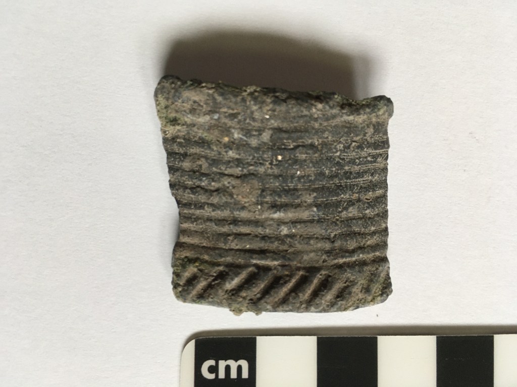
This is the second piece of pottery (a.k.a. sherd) that has turned up on a sandbar after flooding. Like the first one, an archaeologist has identified the pattern as associated with a specific Native American cultural group known as the Great Oasis. What’s more, he thinks that the pieces came from two separate pots. The people who made this pottery mostly lived in northwestern Iowa about a thousand years ago, but must have at least traveled along the Creek valley and left behind these clues. Another archaeologist interpreted an arrowhead–one of about a dozen found along the Creek– to be an Archaic form which means that it could go back as much as ten thousand years. Plus, we know that Dakota families moved along the Creek a little more than one hundred years ago because the homesteaders saw them and talked to them. That means that this stretch of the stream is a “multicomponent site” with a record of several different Native American groups that goes back for hundreds to thousands of years.
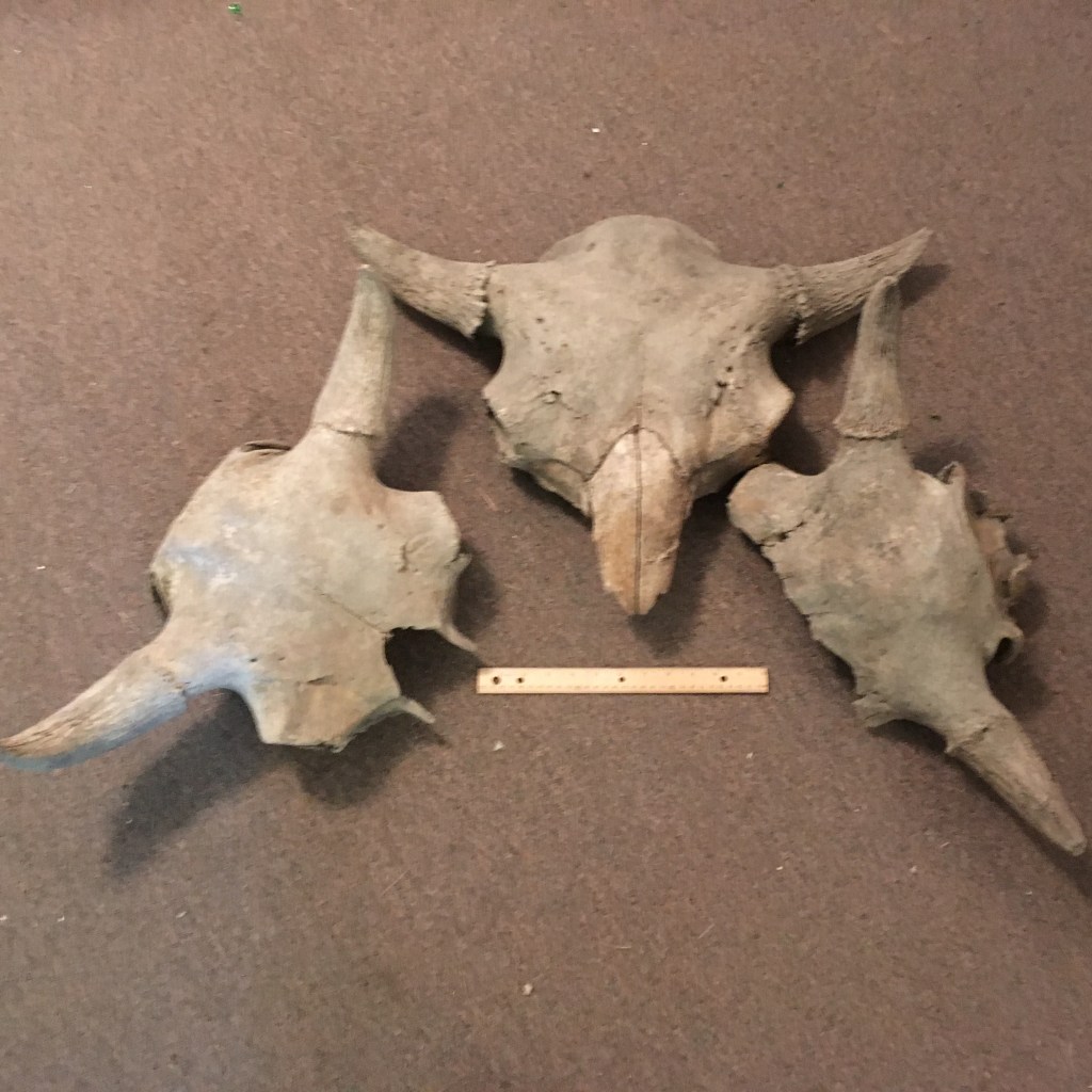
The Native Americans were probably hunting buffalo (technically known as bison) in the valley. The Creek has also shared this part of the story because these three skulls washed out during high water. A paleobiologist told us that they aren’t primitive Ice Age animals, but are probably the newer species that would be available for Native American hunters. However, these weren’t all just transitory hunting parties following buffalo along the Creek corridor because there are also some primitive corn cobs that have eroded out of the banks. That suggests that some of those people actually stopped and raised crops along this route. In fact, an archaeologist who did geophysical measurements on a circular vegetation anomaly has suggested that there may have been the remains of a dwelling in this multicomponent site. She thinks that it was probably built by the Great Oasis people because of the pieces of pottery.
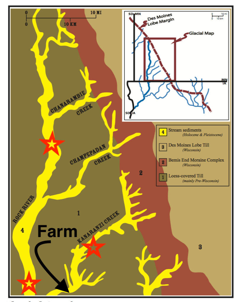
The Kanaranzi is only one of a series of streams that were used as travel corridors by Native Americans. Some of those travelers were from the tall grass prairie with big rivers to the south, but they were challenged by the Dakota who dominated the country of lakes and forests to the north. The three red stars mark places where settlers documented incidents between these travelers from the south and the Dakota people. A battle along the Rock River between the Dakota and Ponca people is described in an early history of Rock County. Farther south along the Rock River our homesteading great-grandparents encountered a Winnebago man who had trailed a wounded elk up from his reservation in the south; he was nervous about the Dakota catching him this far north. And the third incident was a battle between the Dakota and a group of southern people known as the Kansa. It’s described in a history of the nearby town of Ellsworth. That fight may have taken place a few miles north of the Farm and is memorialized in name of the Creek. “Kanaranzi” means “place where the Kansa were killed” in the Dakota language. These three encounters recorded in white history records are probably not the only ones that happened along the streams that flow out of the north and east. The Kanaranzi Creek and Rock River are not the only drainages that have memories of conflict along the corridors. All of these valleys (Unit 4) were originally formed when water coming off a melting glacier (the Des Moines lobe, Units 2 and 3) located just to the north and east, spilled out onto a broad plain of older glacial material (Unit 1).
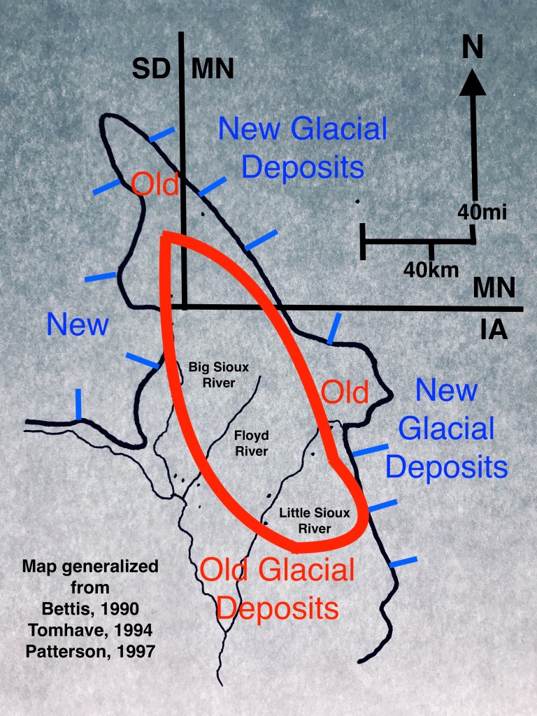
The drainages that form corridors near the Farm are only part of a larger network of old meltwater valleys spread across the transition zone between the new and older glacial deposits. Main stem rivers like the Big Sioux and Little Sioux also provided travel corridors that crossed the borderlands between north and south core areas. The area of newer glacial material has been recognized as a distinctive resource area by a former state archaeologist for Minnesota. He has called it the “Prairie Lakes” region and characterized the various Native American cultures that lived there. Those cultures, like the Dakota, that used the lakes and forests were very different than the cultures, like the Ponca and Kansa, that developed to the south where big rivers and tallgrass prairies were dominant. In fact, those cultural differences and the territories they routinely occupied were probably a root cause of the conflicts documented by the settlers in the corridors near the Farm.
So, the Kanaranzi Creek and the other streams all carry memories of a lot of human activity. The northern core region of forests and lakes in the areas of new glacial deposits and the southern core region of tallgrass and big rivers in the area of old glacial deposits were connected by a network of travel corridors used by Native Americans. In addition, these same landscapes influenced the subsequent development of transportation and commerce in the cultures of later white settlers.
This post uses a number of sources that are only partially acknowledged. If you’d like the complete detailed formal references, please let me know in the comments below (with your email address for a response).
