
Last week’s post described some “treasures” that our grandkids have discovered in the pasture down along Kanaranzi Creek. Some of the artifacts and bones that they found near circular vegetation patches seemed to warrant input from professional archaeologists. That input came as a part of a geophysical mapping project aimed at assessing the significance of the plant circles as possible cache or storage pits.

An archaeologist has identified this arrowhead as possibly related to an Archaic culture. That suggests that people have traveled and lived along the Creek for many thousands of years. It also indicates that this site is “multicomponent” with evidence of use by several different cultures at different times.

Pieces of pottery are more useful than arrowheads for identifying specific cultural groups. Another archaeologist told us that this piece is characteristic of the Great Oasis people. It was found in the vicinity of the possible storage pits. About a thousand years ago, there were a lot of Great Oasis villages in northwest Iowa. Here’s a link to a description of this culture: https://archaeology.uiowa.edu/great-oasis-0
There are also Great Oasis sites in southwest Minnesota, so maybe the Creek was a travel route for these people.
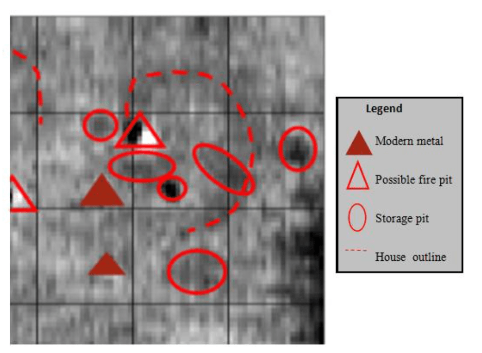
In addition to artifacts and plant patterns, the magnetic properties of the soil support the idea that there was a dwelling and possible storage pits in the area. Measurements mapped and “massaged” by computer procedures show large and small circular anomalies that correspond with the vegetation patterns. The archaeologist who did the study interpreted the larger circle as a possible house outline with associated storage and fire pits. She suggests that this may have been a sort-term habitation site, probably associated with Great Oasis people.
The last Native Americans to travel along the Creek are documented in stories passed down from our original homesteading family. These travelers were probably family groups of Dacotah people who camped near the settlers’ dugout shelter. One story is about how an Indian mother compared her children’s dark hair with the fair-haired settler children. Another describes how the kids living in the dugout would visit with the families camped in tepees nearby. A third story relates how one man asked Great-grandpa to buy supplies for him to avoid getting cheated by the merchant. This latest group of Indian travelers adds another layer to this multicomponent site and the Euro-American homesteaders are yet another layer.

Kanaranzi Creek is one of four or five tributaries of the Rock River that may have been important travel routes for Native Americans. These valleys (shown in yellow) were all produced by melt water streams coming off a stagnant ice sheet (shown in light brown) located along the east side of this map. The map is a simplified version of a map of glacial geology published by the Minnesota Geological Survey. The glacial deposits in the east are part of a resource area known as the Prairie Lakes Region (Southwest Minnesota Archaeology, 1997). Maybe the early travelers were using these corridors to move from one resource region to another. The area to the west and south has very few lakes and so it represents a different set of resources. Isn’t it cool when geology can be used to explain the behavior of people over the centuries? Unfortunately, it doesn’t happen that often!

Pingback: Place-Based Stacked Experiences | Lone Tree Farm on Kanaranzi Creek
Pingback: Cultures Changes | Lone Tree Farm on Kanaranzi Creek